Thursday, September 8, 2011

THE POSTBERG TRAIL

Every time we do an overnight hike with a group of friends, we are reminded how privileged we are in South Africa to have these wonderful facilities in wilderness areas and National Parks. 

A friend had a booking for a party of 12 for the Postberg hike in the West Coast National Park.  This two-day hike is only available during August and September when the Spring wild flowers are at their best.  He phoned the Park office 15 minutes before the opening time on the first day of booking (1st June) to find that there was only one weekend still not booked ??!!   Needless to say, he booked it. 

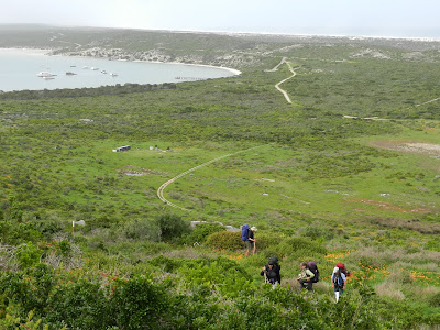
The slopes of the Postberg with Langebaan Lagoon in the background
The West Coast National Park is north of Cape Town and south of Langebaan and Saldanha Bay.  There are limited overnight facilities which means taking a tent and a high density foam mattress.  There is an ablution block with toilets and basins (cold water), a couple of tables, braai facilities with wood, and grids and a portable wash-up stand are provided.  The overall distance of the hike is 27.3km, the first day being 15.5km and the second day 11.8km. (maximum number of people in group – 12)  Water is only available at the start and at the overnight camp, so water bottles must be carried.


The mouth of the Lagoon meets the Atlantic Ocean


We left Cape Town at 7.15 on the Saturday morning,  arriving at the Park at 8.45.  There is secure parking at the start of the hike.   The first  stretch of  the hike crosses a  plain covered with yellow, orange and white and lilac daisies – a sight that was repeated every time we  crossed a plain.  The route is not particularly strenuous, but does have some good uphill stretches  with magnificent views of the Langebaan lagoon and the coast.


Looks like sand in the distance, but those are flowers!


A brief stop among the daisies

The overnight stop is on the coast at facilities which are used by day visitors until 5.00p.m.  So if you are expecting to camp in a remote untouched wilderness area, you will be disappointed.  But then once the day visitiors had left, the ablution block was cleaned and the wood and grids and wash-up stand were delivered. 
Drinks at Sunset

Red sails in the Sunset?
Once the tents were pitched and hiking clothes changed, we gathered on the rocks next to the sea for drinks at sunset.   And then came our evening braai and good conversation.  And,  of course, with night came absolute quiet, except for occasional snuffling and other animal noises.

On the second day the trail passes the  cars after about 6 kms where heavy packs can be offloaded.  We then walked about 2.5kms along 16-mile beach which took us in sight of a wreck.  The path turns into the dunes where we sat and had a light lunch, and then turns and heads back along behind the dunes.  The second day was very much easier, partly made so by being able to do the beach walk without packs.
Oystercatchers and Kelp Gulls

The turnoff with the wreck in the background.
If you are still hungry, or did not bring lunch, there is a shop near the cars at the end of the trail which sells books, hamburgers, hot dogs, drinks, chocolate and chips

For bookings during August and September phone 022 707 9902/3 (before 8.00a.m. if you want a weekend) on the 1st June.

Thursday, August 11, 2011

SIMONSTOWN - WALK TO ADMIRAL'S WATERFALL AND KAYAKING IN FALSE BAY

Our intention had been to join a group of paddlers leaving Long Beach, Simonstown at 9.30, but when we arrived the wind was too strong, so we came up with Plan B.  A walk to explore Simonstown moving in the direction of Admiral’s Waterfall.   We visited the tourist information office, next to Jubilee Square,  and were directed to a 15-minute scenic walk starting on the corner of the Main Road (St George’s Street) and Rectory Lane,   leading up to Runciman Drive.   If you head out for a walk with a positive spirit and an enquiring mind, you will find something of interest.  And we did!


The start of Rectory Lane was reminiscent of the narrow pathways one finds in the coastal villages around the Mediterranean – all it needed was a pot or two of red geraniums.   If you are going up, all roads lead to Runciman Drive.  From there it is a short walk along Victory Way or Barnard Street to the Signal School or Klaver steps, which lead up to  the grave of Just Nuisance, a war memorial and an old hospital.    The Steps head up and up, and every time you think you are at the top, there is another corner and more steps, with the quaintest stone walls on either side.  There must be several hundred steps!


At the top are a group of old, rather dilapidated, official buildings.  There is a monument to men from the Simonstown Naval Base who died during the First World War and the grave of Just Nuisance, a Great Dane who from 1939 to 1944 served with the Royal Navy, on the base ship HMS Afrikander, and is thought to be the only dog ever to do so.  Click here for more about 'Just Nuisance'.


The ‘official buildings’ used to be the Naval Sanatorium  - completed in 1904, the Sanatorium was for the care of sick and injured seamen.  It was once an attractive building and is needing  care and restoration and would make a perfect museum/restaurant/concert venue.   The metal structures leading up to the top of the mountain were once part of a cable car system linking the dockyard with the hospital.  It was initially used to transport materials, equipment and labour, and then staff and patients.  An efficient method of keeping convalescent patients away from the less salubrious aspects of life in Simonstown.


                Klaver Steps

Our next stop was the Waterfall.  If you turn left when you come back down to the bottom of  Klaver Steps, follow Barnard street until you come to the gravel path which leads to the Falls – about a 15 minute walk.  At the bottom of the Waterfall is a dam that served as a weir once collecting and providing a source of fresh water for Simonstown.  It is not difficult to walk through the water, and clamber over a few rocks for a short walk up the kloof.
We then made our way back to St George’s Street having walked the best part of three hours.

Note the weir wall - we have not had much rain!

Looking at Simonstown from the Waterfall


*****************

The wind was by now noticeably gentler and the sea looked calmer.  It looked like a perfect winter's day for a paddle - crisp and clear with little wind. There is a launching area for kayaks at Bertha’s Landing, and good parking on either side of the beach.  The water in the yacht harbour area was quite smooth but as we rounded the ‘bullnose’ we hit a bit of turbulence from the water bouncing back from the wall.  The water did calm down as we paddled to Ark Rock, then turned towards Windmill Beach and back towards the harbour. 


Anyone wanting to try some kayaking with a group of paddlers who launch from Simonstown  - who knows you may become a regular - go to the Paddlers' website  and the Cape Kayakers blog.


More about kayaking in a later post.


Tuesday, July 12, 2011

BLOUBERG - THE MyCiTi BUS AND CYCLING

Yip, we took those bikes out of the storeroom, last used in May 2010.   We have been wanting to try out the first MyCiTi bus route and Sunday was the perfect day.  Blue sky, no wind and not too cold - a perfect Cape Town winter's day.

The Terminus at the Civic Centre
The cycle ride along the Main Road to the terminus beneath the Civic Centre in the CBD took us 30 minutes.  Then we became tourists in our home town - tickets for two of us were R10.00 each. (bikes go for free).   We then had to join the correct queue for Table View, not the Airport, Gardens, or Waterfront queues.  We waited about 10 minutes for a bus. Although bicycles are allowed on the buses, it would be better to enter the doors towards the front of the bus - opposite these doors is the area for wheelchairs and bicycles.  Wheelchairs get preference, so wait for the next bus if the space is taken by a wheelchair.  Bicycles lean up against three seats facing the door and are strapped in with the seat belts.   If those seats are already taken, wait for the next bus unless there are other seats available and the passengers do not mind moving.   Bit tricky this!  Bicycles are not allowed on the buses during rush hour on weekdays.  http://www.capetown.gov.za/en/Myciti/Pages/default.aspx

Our bus was full  (about 1.30p.m). - so we had to stand next to our bikes, but there are sufficient straps to hang on to.  The great thing about being a tourist in your home town, is that you begin to behave like one, and start talking to others on the bus.  The bus route goes along the railway line out of town, until it takes a left turn under the N1, and follows the old railway line through the centre of Paarden Eiland.  The line crosses the Black River canal, turns onto Marine Drive and keeps to the centre of the road until it reaches Table View. The Table View terminus is at the beginning of Blaauwberg Road.  We hauled our bikes off the bus, and looked around, trying to work out where to catch our bus to Blaauwbergstrand.  The buses to Parklands and Blaauwbergstrand leave from the same building closer to the West  Coast Road.  Inside the terminus are plans of each route with the stops listed. (as in the Paris or London Underground) Once on the bus we could work out where the best stop for us was - Kleinbaai which took us very close to Onse Huisie where we sat outside under an umbrella with a view of the sea and ordered lunch - chicken salad and a pepper burger.  Onse Huisie was very full and the service took longer than expected for a late lunch!!

The beach at Blouberg

We had decided to ride back along the cycle route.  This is a must-do for every Sunday cyclist. We followed the beach until we turned up Otto du Plessis Drive.  At the Blaauwberg Road/West Coast Road corner in Table View, we turned onto the cycle track which follows the MyCiTi bus route. The route is along the coast side of the road until Paarden Eiland when you swing inland.  Except for a short way on the pavement, you are separated from the cars by a planted verge.


Milnerton Lagoon
Cycling out of Paarden Eiland
At the Lower Church Street bridge, it is possible to leave the cycle route by riding up to the bridge along a pedestrian way, and  ride to Lower Main Road (Albert Road) or the Main Road. We cycled home along Lower Main Road.  (1 hour and 30 minutes from Blaauwberg to home)


Saturday, July 9, 2011

NIEUWOUDTVILLE AND OORLOGSKLOOF

We enjoy exploring new places and hiking, and wanted to organise a five day hike in a new area for a group of hiking friends.  We heard about the Oorlogskloof Nature Reserve, near Nieuwoudtville, which sounded as if it might be worth further research.  The Reserve has three day hikes of varying lengths and two longer hikes (4-5 days and 5-7 days).  We decided to take a few days off and do an advance recce.

One of the cracks on the Trail - there are a
few ladders to negotiate.
We left Cape Town on a Sunday morning, and arrived at our self-catering cottage  – ‘Bokmakierie’ shortly after 2.00p.m.   Bokmakierie is on a smallholding on the outskirts of Nieuwoudtville, but is within walking distance of the  village (5 minutes).    We settled in and slowly started to unwind, and appreciate the view from the kitchen door -  the sheep next door,  a windmill close enough to hear it turning, and green fields as far as the eye could see (this was July!)   We  spent a couple of hours strolling round the village,  exploring some very old dilapidated stone houses,  and the stone buildings along the main road.   Back in our temporary home, we made a fire,  put our electric blankets on to warm up the bed, and curled up on the couch with a plate of spaghetti bolognaise and a couple of good books .   The next morning (Monday) we booked an evening meal at a restaurant in the Main Road – ‘Die Nedersetting’ and  picked up our permits at the Department of Nature Conservation for a day hike in the Oorlogskloof  Nature Reserve which is 16km out of Nieuwoudtville.  We choose the  Leopard Trap Day Hike which is 15.5km and passes a very old stone leopard trap and a magnificent view of the knersvlakte, (north of  Vanrhynsdorp) from the top of the escarpment.  The trail was pretty rugged for the first couple of kms, and we found ourselves clambering over large rocks, climbing ladders and squeezing through cracks on koppies.

 
The Leopard Trap
We wondered how we would fare with a heavy pack,  particularly after one km took us an hour to walk.   The trail soon became easier and we began to make good time.   The Reserve estimated the 15.5km would be a 6 to 9 hour hike.  We managed 6¼ hours, which excluded our stop for lunch.   The trail took us through  renosterbos and Bokkeveld fynbos.  We arrived back at the car feeling well exercised, and agreed that we would organise a group hike to return to Oorlogskloof Nature Reserve in late September.            http://www.footprint.co.za/oorlogskloof.htm

That evening was our ‘night out’ at 'Die Nedersetting'. We were greeted by Wessie  and  shown to our table in front of a roaring fire.  We  were able to ask for wine by the glass which suited us and, as we had chosen our meal  that morning,  we were soon tucking into venison pie and vegetables.  Wessie and Hester,  the  co-owners, were quite happy to answer our  questions about the town, ‘boerekos’ and tips on the cooking thereof,  and they told us about their ideas of expanding the accommodation and dining facilities.  We ordered malva pudding with custard for dessert, and coffee, and left feeling well warm, relaxed and well fed after perfect Afrikaner hospitality.      http://www.getaway.co.za/article/nedersetting-restaurant-Niewoudtville

Tuesday was our sightseeing day.  Nieuwoudtville has many beautiful, old, Victorian-style, sandstone buildings built from the locally quarried stone.  One such building is the Dutch Reformed church built with local, dressed sandstone  in 1906/7 on land donated by the Niewoudt brothers – well worth a visit.    The local garage has a fascinating collection of vintage motor bikes and dinky cars.

Nieuwoudtville Falls
A short way out of town, towards Loeriesfontein,  are the Nieuwoudtville Falls.   At the confluence of the Gras Rivier and Willem Rivier  which is called Maierskloof, are the falls.    Both the Gras and Willem Rivers begin closer to the edge of the escarpment and flow inland and together form the Doring River.  The falls are spectacular and fall 100 metres into a large pool far below in a deep ravine.

The road ends at Loeriesfontein which is a town well worth a visit.  The Fred Turner Museum has a fascinating collection of Afrikaner memorabilia and a collection of windmills.    The elderly curator heard that we were visiting, and came to open the hall specially for us!  

On the return trip, we took the detour to the Kokerboom or Quiver Tree forest. This is not far from the main road and is the largest and most southern forest of Aloe dichotoma.  These Aloes only grow on north-facing slopes and flower in June/July.

A Kokerboom in flower
We arrived back at ‘Bokmakierie' as the sun was setting and  braaied our locally bought lamb saddle chops and boerewors over the sitting room fire.  A perfect end to our day.

Wednesday was our ‘return home’ day.  We slowly packed up, fed our left-over milk to a wandering cat and  drove south towards the Matjiesfontein Farm Stall.  Unfortunately it is closed over winter, but we stopped at the glacial floor, 10km out of Nieuwoudtville.  These are tracks in the stone, formed by the movement of ice over Southern Africa when it migrated over the south pole about 300 million years ago.  Interesting,  and fascinating if you happen to be a geologist.

We would highly recommend a visit to Nieuwoudtville and the Oorglogskloof Nature Reserve for a short break.  We arrived back home refreshed, and well exercised having got good value for our money and time.